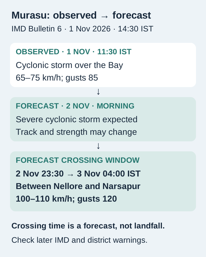
Cyclone Murasu was forecast to cross the Andhra Pradesh coast between Nellore and Narsapur from 11:30 pm IST on November 2 to 4 am on November 3, according to IMD’s National Bulletin 6 issued at 2:30 pm IST on November 1. The forecast crossing intensity was 100–110 km/h, gusting to 120 km/h. This is a forecast window, not a report of landfall.
The bulletin followed the deep depression’s strengthening into a cyclonic storm over the southwest and adjoining west-central Bay of Bengal. Its 11:30 am observation placed the centre near 12.1°N, 85.3°E. The immediate issue for coastal residents is that deteriorating seas, wind and rainfall can affect travel and shelter before the centre reaches land.
A window that crosses midnight
IMD expected west-northwestward movement and strengthening into a severe cyclonic storm around the morning of November 2, followed by northwestward movement towards the coast. The stated 23:30–04:00 crossing window spans two calendar dates. A headline saying only “November 3” omits the late-November 2 part of that forecast.
The distinction between observation and prediction is essential. The 11:30 am November 1 intensity was 65–75 km/h, gusting to 85; 100–110 km/h with gusts to 120 was the forecast near crossing. The positions and intensities can change in later bulletins, so both the issue time and the observation time are shown here. The figures here are tied to Bulletin 6’s stated issue time.
Rain and surge extend the area of concern
For coastal Andhra Pradesh, IMD forecast heavy to very heavy rain at a few places and isolated extremely heavy rain on November 2 and 3. South Odisha was forecast to have isolated heavy to very heavy rain on November 3 and 4; Rayalaseema also faced heavy to very heavy rain on November 2 and 3. Telangana’s warning included isolated extremely heavy rain on November 3.
The bulletin also forecast a surge of about one metre above astronomical tide in low-lying south coastal Andhra Pradesh during landfall, with peak surge expected in Bapatla, Krishna and Prakasam districts. That is a surge forecast relative to the tide, not an observed water level or a uniform flood depth everywhere. Rain and flooding hazards remain relevant away from the predicted crossing point.
What residents and fishermen can do
IMD called for fishing operations to be suspended and warned fishermen not to venture along or off the Andhra coast from the morning of November 2 until the afternoon of November 4. It advised moving coastal hutment residents to safer places, avoiding vulnerable structures and waterlogged areas, and following traffic advisories. Residents should follow local evacuation instructions and use the IMD portal’s district warnings for their location and their district administration’s evacuation and traffic instructions.
The practical conclusion is to prepare before the overnight crossing window, while treating each later IMD bulletin and district instruction as the authority for changes. The risk is not confined to the hour of landfall: rough seas, rain and potential flooding have their own periods. Keep the forecast date, location and warning period together when deciding whether a trip or fishing activity can proceed.
Prepared by the editorial team from official records and reviewed public sources.
- IMD National Bulletin6 BOB/09/2026, issued14:30IST Nov1 ↗
- IMD current bulletin and district warnings portal ↗
- Hindustan Times Nov1 live coverage ↗