The National Weather Service in Fairbanks has issued winter storm warnings for parts of Interior Alaska, with 18–36 inches of snow forecast above 2,500 feet in the eastern Alaska Range from Monday, October 19, through early Thursday, October 22. Fairbanks and Nenana remain under a winter storm watch for 4–8 inches possible Tuesday into Wednesday. These are different forecast areas and alert levels.
The warnings were issued at 2:59 p.m. Alaska Daylight Time on October 18, upgrading earlier watches as the storm approached. The timing matters for travel at the start of the week: the eastern range warning begins Monday morning, while several Interior warnings begin Monday night or Tuesday. All times below are AKDT, the local time in the affected areas.
Selected alerts: all times AKDT
| Area / alert | Period | Forecast snow |
|---|---|---|
| Eastern Alaska Range / warning | Oct19 7am–Oct22 4am | Above 2,500 ft: 18–36 in; below: 12–24 in |
| Delta/Fortymile/Upper Tanana / warning | Oct19 10pm–Oct21 4pm | Generally 6–12 in;local exceptions in text |
| Upper Chena/White Mountains/southern-eastern Yukon Flats / warning | Oct20 10am–Oct21 4pm | Generally 5–10 in;sharp local gradient |
| Fairbanks/Nenana / watch | Tuesday morning–Wednesday afternoon | 4–8 in possible |
| Denali Borough / watch | Monday afternoon–Wednesday afternoon | 6–12 in possible;less north/west of Healy |
NWS October 18, 2:59 pm update. Forecasts can change;not statewide totals or road-closure notices.
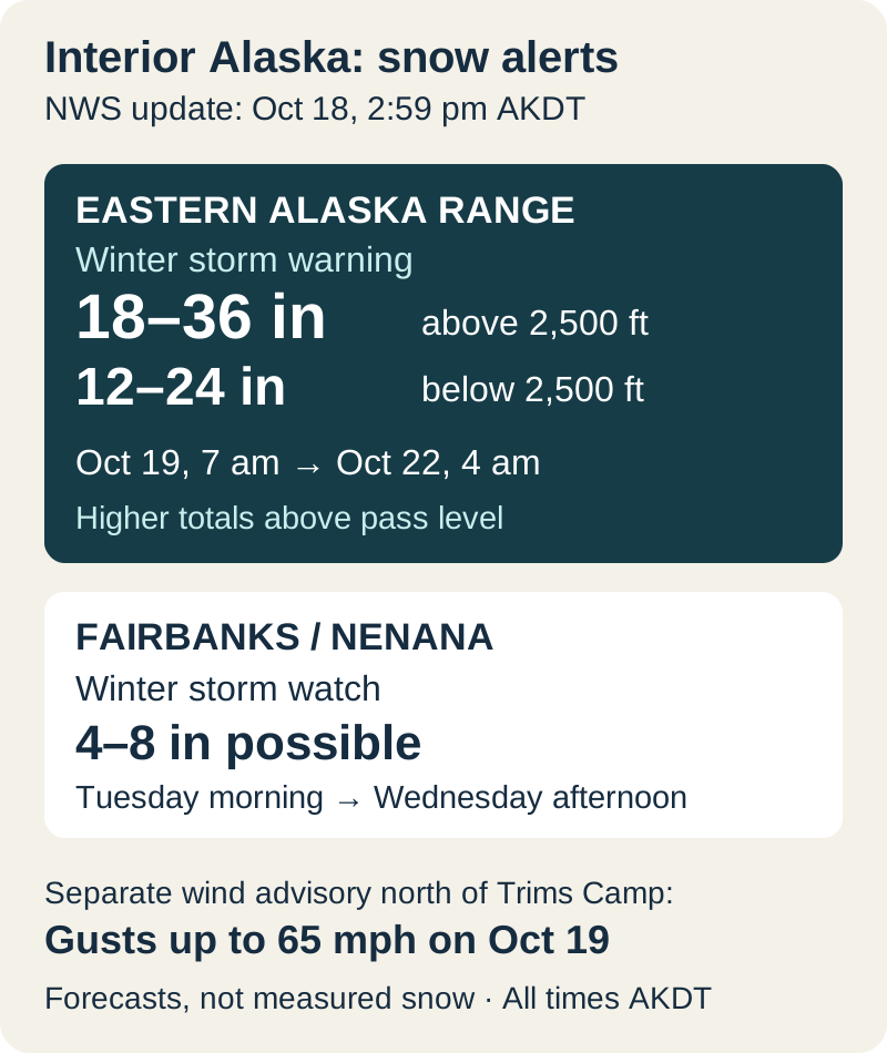
Where warnings apply and when they start
In the eastern Alaska Range, the warning runs from 7 a.m. October 19 to 4 a.m. October 22. NWS expects 12–24 inches below 2,500 feet and 18–36 above it, with still higher amounts above pass level and gusts up to 40 mph. The office says travel may become extremely difficult or impossible as blowing snow reduces visibility.
Delta Junction, Fortymile Country and the Upper Tanana Valley are under a warning from 10 p.m. October 19 to 4 p.m. October 21. The general range is 6–12 inches, but Northway to the Alcan border is forecast at 2–5, and Tanacross to Dot Lake could see 12–18. A separate warning for the Upper Chena valley, White Mountains, Eagle Summit and southern/eastern Yukon Flats runs from 10 a.m. October 20 to 4 p.m. October 21, generally for 5–10 inches.
Fairbanks uncertainty and the wind before the snow
Fairbanks North Star Borough and Nenana remain on watch for Tuesday morning through Wednesday afternoon. NWS stresses uncertainty in where heavier snow will fall, leaning toward more near Eielson and less in and west of Fairbanks. Denali Borough is also on watch, Monday afternoon through Wednesday afternoon, for 6–12 inches possible. Its forecast drops sharply north and west of Healy; Anderson may get only a few inches.
The strongest wind number belongs to a separate advisory north of Trims Camp: south winds of 30–40 mph, gusting to 65 mph, from midnight starting October 19 until 10 p.m. that day. NWS warns that high-profile vehicles can be difficult to drive in those winds. It then expects winds to turn northerly as heavy snow builds Monday into Tuesday and Wednesday. The 65 mph figure is not the snow-warning gust forecast for every affected area.
Match the forecast to the road you will use
Before departure, open NWS Fairbanks and select the forecast and alert covering the destination and mountain pass. Then use Alaska 511’s Map, Text View or Alerts, or call 511, for road information along the route. The warning advises carrying a flashlight, food, water and warm clothing if travel is necessary. A forecast total alone cannot establish whether a particular road is open.
The practical distinction is between the eastern range’s prolonged, elevation-dependent warning and the less certain snow placement around Fairbanks and Denali. Check both the area and the active period, especially when a journey crosses from a town into a pass. The next NWS update and Alaska 511 road report should guide any change to departure time or route.
Forecasts use the October 18 afternoon NWS notices. Conditions are local to Alaska and may change with subsequent updates.
- NWS Fairbanks: current warnings, watches and advisories ↗
- NWS Fairbanks forecast office ↗
- Alaska 511 road conditions ↗