The India Meteorological Department (IMD) forecasts that the Bay of Bengal system will cross the Andhra Pradesh and Yanam coasts between Bapatla and Visakhapatnam by the forenoon of 28 October 2026. Its National BulletinNo. 2, issued at 02:00 IST on 25 October, projects a very severe cyclonic storm with sustained winds of 115–125 km/h, gusting to 140 km/h, at that stage. This is a forecast, not an observed landfall.
The bulletin’s observation was at 23:30 IST on 24 October, when the system was still a depression over the east-central and adjoining south-east Bay. IMD issued a yellow Pre-Cyclone Watch for Andhra Pradesh and adjoining south Odisha. The practical issue for coastal readers is that hazardous sea conditions and heavy-rain warnings begin before the projected crossing date.
Marine precautions begin before the forecast landfall
| Area | IMD no-venture advice |
|---|---|
| East-central and adjoining south-east Bay; around Andaman Islands | Through 26 October |
| West-central and adjoining north-west/south-west Bay | 26–28 October |
| Along and off Andhra Pradesh–Odisha coasts | 27–28 October; follow subsequent advisories |
National BulletinNo. 2, issued 02:00 IST 25 October. These are marine warning windows, not a prediction of landfall at every listed coast.
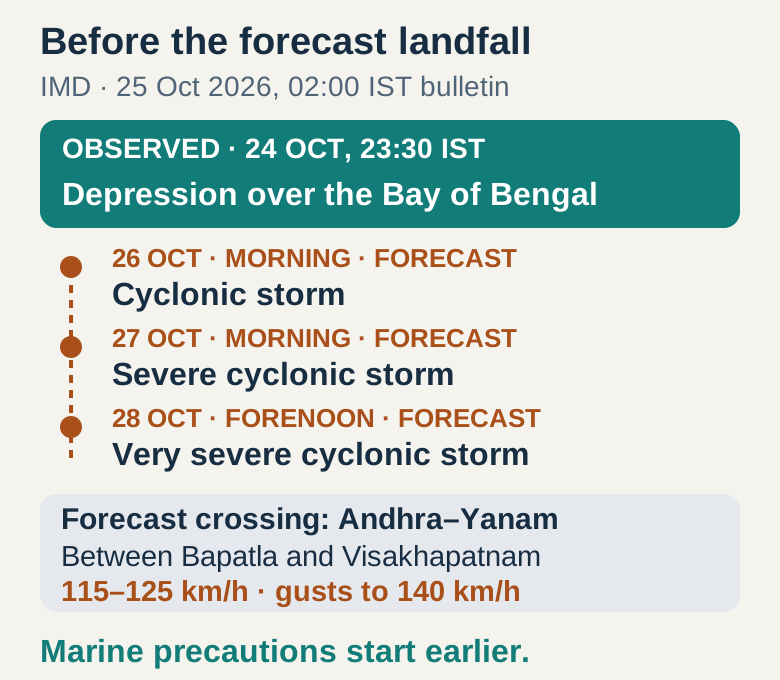
From an observed depression to a forecast coastal crossing
IMD located the depression near 15.5°N,91.0°E, about 860 km east-southeast of Visakhapatnam, at the observation time. It expected movement generally southward before a turn west-northwestward on 25 October, strengthening to a cyclonic storm by the morning of 26 October and a severe cyclonic storm around the morning of 27 October. The projected approach to Andhra on the 28 th is the next stage of that sequence.
The forecast track has an uncertainty cone, so the coastal stretch is more useful than a promise about one town or an exact hour. IMD’s tropical outlook also discusses differences among model tracks and timing. Readers should treat the dated intensity and crossing window as the current planning basis in this bulletin, with subsequent official updates able to change both. The named local hazards matter even while the final track remains a forecast.
Rain and sea warnings reach beyond the landfall window
For Andhra Pradesh, the bulletin forecasts heavy to very heavy rain at a few places and extremely heavy rain at isolated places on 27–28 October. Odisha has heavy to very heavy rain on the 27 th, with isolated extremely heavy rain on the 28 th; eastern Telangana also has isolated extremely heavy rain forecast for the 28 th. These are forecasts for specified parts of each state, not a claim that every district will experience the same rainfall.
At sea, IMD advises fishermen not to venture into the east-central and adjoining south-east Bay and waters around the Andaman Islands through 26 October; the west-central and adjoining north-west/south-west Bay during 26–28 October; and along and off the Andhra Pradesh–Odisha coasts during 27–28 October. Its action section also directs coastal fishermen to follow warnings from the 27 th onward. The table therefore gives the stated windows without treating their end as an automatic all-clear.
Use the lead time for specific preparations
For fishing trips, follow the relevant no-venture window and the latest harbour or fisheries advisory; IMD says small-boat movement is unsafe in affected conditions. Coastal residents should follow local evacuation instructions, avoid vulnerable structures and stay away from frequently waterlogged routes. These are preparations and official recommendations, not a report that evacuations or transport closures have already happened. Travellers can check route and traffic advisories before departure instead of waiting until the forecast landfall morning.
The IMD cyclone page below provides National Bulletin, Track and Wind Warning links; the district-warning page supplies the local warning view. Check the issue time and your district together. The central lesson of this forecast is temporal:28 October is the projected coastal crossing, while marine precautions and rain precautions start earlier. Planning around those earlier hazards is more useful than waiting for a final cyclone name or assuming the forecast track is settled.
Based on IMD National Bulletin No. 2, issued at 02:00 IST on 25 October 2026 using the 23:30 IST observation on 24 October. Later stages are forecasts. Use subsequent bulletins and district warnings for current local decisions.
- IMD: National Bulletin No. 2, issued 02:00 IST on 25 October 2026 ↗
- IMD: current cyclone bulletins and marine warnings ↗
- IMD: district warnings ↗
- IMD: Tropical Weather Outlook based on 18:00 UTC on 24 October ↗