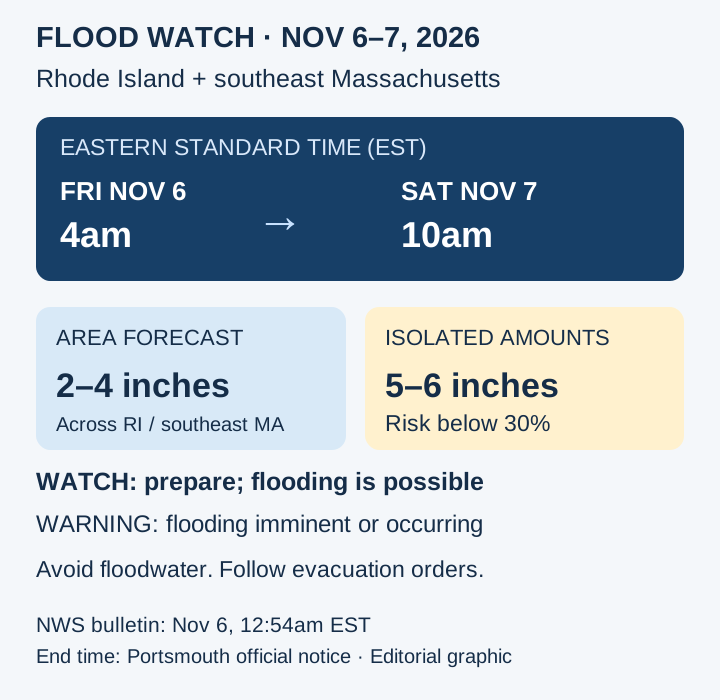
A Flood Watch covers Rhode Island and parts of southeastern Massachusetts from 4 am EST Friday, November 6, through Saturday morning, November 7. Portsmouth’s official notice specifies a 10 am EST Saturday end. The National Weather Service expects 2–4 inches of rain across the area, with a below-30-percent risk of isolated 5–6 inch totals. Residents in flood-prone places should prepare and monitor later warnings.
The NWS Boston/Norton office continued the watch in its 12:54 am EST Friday bulletin as periods of heavy rain were forecast through Saturday morning. Portsmouth had posted its local notice on November 5. This makes the watch relevant to Friday travel and the start of the weekend, while leaving actual flood conditions dependent on where rain falls and how runoff develops.
Which places and hours are covered
The bulletin names Rhode Island’s Providence, Kent, Bristol, Newport and Washington counties, including Block Island. In Massachusetts, it covers Barnstable, Dukes, Plymouth and Bristol counties. The window is expressed in Eastern Standard Time: Friday at 4 am to Saturday morning, with the town notice stating 10 am. It is not a watch for every Massachusetts county or the whole of New England.
The main rainfall forecast is 2–4 inches. The NWS separately identifies a low risk, below 30 percent, of isolated 5–6 inch amounts. Portsmouth’s earlier notice mentioned isolated amounts up to 5 inches; the newer NWS bulletin supplies the updated range and its probability limit. The larger figure should not be treated as the expected total at every address.
Why the watch matters before water appears
Excessive runoff could raise rivers, creeks and streams and flood low-lying places. The NWS also flags urban areas and poor drainage, where debris can clog storm drains and ditches. Those are pathways through which heavy rainfall can become a local problem; the watch itself does not establish that a particular road or property is already flooded.
A Flood Watch means conditions are favourable for flooding and preparation is warranted. A Flood Warning means flooding is imminent or occurring. That distinction explains why the current instruction is to stay alert for later warnings rather than read the watch as either a confirmed disaster or a guarantee of safety until it expires.
Prepare now, act on warnings and visible hazards
Use the NWS watch page and later local forecasts to follow changes for the relevant location. If flooding develops, NWS guidance is to avoid driving or walking through floodwater and never go around barricades. Follow evacuation instructions immediately; people in flood-prone areas should move to higher ground when needed. These actions address actual hazards rather than relying on a regional rainfall total alone.
The practical judgment is to keep the window, location and alert level together. A place under the watch needs readiness; a later warning or visible flooding requires action even if nearby places receive less rain. The next useful updates are changes in the watch or warning coverage and local conditions, not an assumption that the isolated 5–6 inch maximum will occur everywhere.
Prepared by the editorial team from the official records and attributed reporting listed below. Forecast times, geographic scope and uncertainty are retained.
- NWS Boston/Norton: November 6 Flood Watch ↗
- Town of Portsmouth: November 5 watch notice ↗
- NWS: Flood Watch versus Warning ↗
- NWS: During a Flood ↗