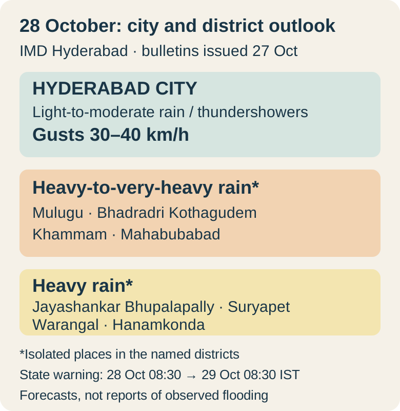
Hyderabad is forecast to have generally cloudy skies with light-to-moderate rain or thundershowers and gusts of 30–40 km/h on 28 October 2026. The India Meteorological Department’s city impact forecast covers all 12 listed city zones. The heavier warning in the state bulletin applies to named districts elsewhere in Telangana, so it should not be read as a very-heavy-rain forecast for every Hyderabad neighbourhood.
The distinction matters as IMD’s 27 October press release described very severe cyclonic storm Arnab over the west-central Bay of Bengal and forecast it to cross the Andhra Pradesh and Yanam coast on 28 October. That is the dated cyclone context for the regional weather outlook, not a report that landfall has occurred. Coastal cyclone wind speeds also should not be transferred to Hyderabad’s inland forecast.
What the city and district bulletins say
The city bulletin, issued at 13:00 IST on 27 October, gives the same 28 October description for zones including Uppal, LB Nagar, Khairathabad, Charminar, Kukatpally, Secunderabad and Shamshabad. Its expected-impact column is marked “Very Low”. That assessment accompanies a forecast containing thunder and gusty winds; it does not remove the need to respond to lightning or a sudden local shower. No city-wide closure or disruption is established by this bulletin.
The state forecast issued at 20:30 IST on 27 October separates the districts by expected rainfall. Isolated heavy-to-very-heavy rain is forecast in Mulugu, Bhadradri Kothagudem, Khammam and Mahabubabad. Isolated heavy rain is forecast in Jayashankar Bhupalapally, Suryapet, Warangal and Hanamkonda. The earlier 14:00 IST press release labels those two groups orange and yellow respectively. These are district-level forecasts, not a claim that every location in each district will receive the same amount.
Match the warning window to the journey
The 28 October state warning period runs from 08:30 IST on 28 October to 08:30 IST on 29 October. It therefore crosses midnight. The city’s zone-by-zone table and the state’s 24 hour warning serve different decisions: one helps a Hyderabad commuter plan a local journey; the other helps someone travelling toward an eastern district check the destination as well as the starting point.
Before setting out, open the IMD Hyderabad website and use its city forecast, state forecast and latest nowcast links. Match the issue date and warning period to the journey, then check the destination district. If a thunderstorm develops, follow the bulletin’s advice to take shelter in a safe building and avoid sheltering beneath trees. Travellers should use the relevant operator’s actual notice for a cancellation; a weather forecast alone does not establish that a train or flight has been cancelled.
A regional forecast needs a regional decision
The regional comparison gives a more useful plan than a single statewide headline. A journey inside Hyderabad calls for rain and thunderstorm precautions under the city forecast; travel toward the named heavier-rain districts calls for checking their more severe warning before departure. The city impact label and the district warning answer different geographic questions and can both be valid at the same time.
For 28 October, the verified Hyderabad answer is cloudy weather, light-to-moderate rain or thundershowers and gusts of 30–40 km/h, based on the 27 October bulletins. The four heavy-to-very-heavy-rain districts should remain clearly identified when sharing that outlook. A later IMD bulletin can change either forecast; the useful follow-up is whether the city description or destination-district warning changes, rather than treating the cyclone’s coastal forecast as Hyderabad’s weather.
Based on the dated official bulletins linked below. Forecasts are distinguished from observations and confirmed outcomes.
- IMD Hyderabad: city impact forecast, 27 October 13:00 IST ↗
- IMD Hyderabad: state bulletin, 27 October 20:30 IST ↗
- IMD Hyderabad: press release, 27 October 14:00 IST ↗
- IMD Hyderabad: forecasts and nowcasts ↗